
Christopher Columbus’s “Enterprise of the Indies” and the subsequent period of European transatlantic expansion traditionally mark the beginning of the Early Modern era, with a paradigm shift characterized by a dramatically new perspective on the world and the universe. However, notwithstanding the significance of the events of 1492, the cultural background of Christopher Columbus’s ambitious project was rooted in the Christian cosmographic tradition of medieval Europe. A survey of cosmographic knowledge at the dawn of the so-called Age of Discovery, with a special focus on Columbus and his known readings, highlights the way early modern cosmography was characterized as much by continuity as novelty. Tellingly, Columbus perceived himself not as ushering in a new era of exploration so much as fulfilling traditional prophesy: religious and scholarly knowledge was difficult to disentangle from the technical and practical knowledge gained by advancements in navigation and mapmaking.
The intellectual framework of late medieval Europe had been undergoing substantial developments and changes from at least the 13th century. The introduction of Aristotelianism and Arabic science and the establishment of the first universities in the 12th century revolutionized the system of learning in the West and opened up new perspectives in the study of nature. By the 13th century, intellectuals were trying to connect the newly recovered knowledge to the traditional authorities. Besides the development of scholastic theology, culminated in Thomas Aquinas’s Summa Theologiae , encyclopedias such as Vincent of Beauvais’s Speculum Naturale attempted to provide a summa of knowledge that incorporated a range of existing sources. The circulation of new texts encouraged the development of new and original ways of thinking about the universe and natural phenomena. A fundamental role in medieval history of science was played by the 13th-century English philosopher Roger Bacon, who discussed in his Opus Maius the importance of empiricism and promoted the application of mathematics to all fields of scientific inquiry, ranging from optics to astronomy and geography. The eventual integration of Latin Christian and Islamicate knowledge, as well as the compilation of encyclopedic works across Latin, Greek, Arabic, and Hebrew traditions, offered organic repositories of medieval thought in the 14th and 15th centuries.
Cosmographic knowledge in this period was inseparable from this broader transition in late medieval and early Renaissance knowledge. Bacon’s book, for example, included a map of the world, and even discussed the extent of the oceanic distance separating Spain from India.1 At the turn of the 15th century, his observations were excerpted and copied into the influential cosmographic compendium Imago Mundi , compiled by cardinal Pierre d’Ailly. Another major event around that time was the recovery and Latin translation of Ptolemy’s Geography .2 Both Pierre d’Ailly’s and Ptolemy’s books are among Christopher Columbus’s known readings, the former preserved in a copy annotated in the Admiral’s own hand.3 (Columbus was granted the title of “Admiral of the Ocean Sea” by Spanish kings and scholars continue to refer to him by this moniker.) One more work rediscovered in the context of the humanist revival was Pomponius Mela’s De chorographia , a 1st-century geographical treatise contemplating, among other things, the possibility of the existence of “Antipodes” in the southern hemisphere. In this sense, Columbus’s travels did not usher in modern cosmography or represent a sharp break with the past so much as build upon syntheses of existing knowledge bases.
mapping the known world
The evolution of epistemology and the study of nature in the late medieval period went hand in hand with developments in the cartographic representation of the world. According to the medieval cosmographic system, the earth was suspended at the center of a universe organized in concentric spheres or heavens, and all habitable land existed in the planet’s northern hemisphere. Such land was distributed across three continents surrounded by an all-encircling ocean, according to a scheme that is traditionally known as “T-O”. In T-O maps, the arms of the T represent a combination of bodies of water separating the three continents, and the O represents the surrounding ocean.
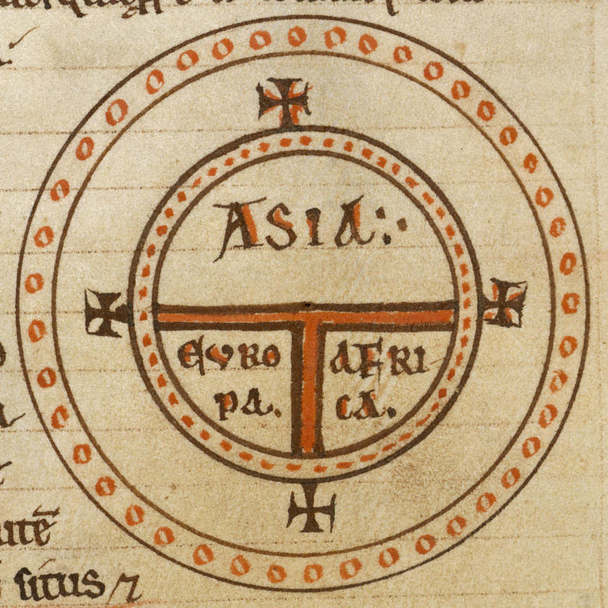 Figure 1: Diagrammatic T-O map showing Asia, Europe, and Africa surrounded by water. From Isidore’s
Etymologies
(12th century), original located at the British Library (shelfmark: Royal 12 F. IV, f.135v).
Figure 1: Diagrammatic T-O map showing Asia, Europe, and Africa surrounded by water. From Isidore’s
Etymologies
(12th century), original located at the British Library (shelfmark: Royal 12 F. IV, f.135v).
The idea of the impossibility of life in the southern hemisphere (virtually lying on the back side of traditional T-O maps)4 derived from the theory of climate zones, first described by Macrobius in the 5th century. The equatorial area, characterized by unbearable heat, was considered a “torrid zone” incompatible with human life and impossible to trespass. Thus, the southern hemisphere was unlikely to be inhabited by humans. Macrobius himself and other ancient authorities, however, were open to the possibility of the presence of a landmass in the southern waters: an unreachable fourth continent. This was the opinion, for example, of the influential encyclopedist Isidore of Seville.
Between the 14th and 15th centuries, while medieval T-O mappae mundi continued to survive, detailed portolan charts started to appear, providing more and more useful tools for navigators. At the same time, with the rediscovery of Ptolemy, the introduction of the system of latitude and longitude coordinates revolutionized the technique of mapmaking – even though the representation of the world offered in his Geography constituted to some extent a step backwards from that of late medieval maps such as the Catalan Atlas (1375) or the Fra Mauro Map (c. 1450), which had already incorporated information from Arabic geographers and European travelers to Asia. At any rate, maps produced in this period are characterized by a great degree of experimentalism. A relevant example is the late 15th century work of Henricus Martellus Germanus, the first cartographer to include the Cape of Good Hope on the basis of the recent travels of Bartholomew Diaz but who continued to depict the rest of the world in a way that was quickly becoming obsolete.5 Even though Diaz’s expedition had disproven Ptolemy’s claim that South Africa was linked to East Asia by a strip of land, Martellus’s maps bears a remnant of Ptolemy’s theories, in the form of a large peninsula extending from the Eastern limit of the Asiatic continent towards Africa.6
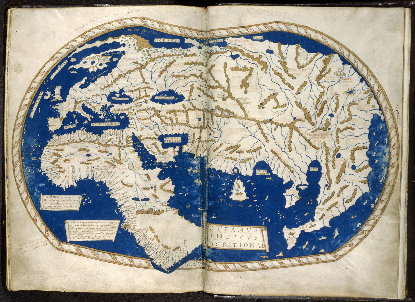
Figure 2: Henricus Martellus’s world map, c. 1490, still Ptolemaic in structure but showing the Cape of Good Hope as well. Original located at the British Library (shelfmark: Add MS 15760).
Another famous work by Martellus, a large world map produced in 1490 and now preserved at Yale, represents Japan off the coast of Asia, and proposes a fairly narrow estimate of the distance between the island and the west coast of Europe: virtually, only 90 degrees of longitude.7 Increased global travel had resulted in clear cosmographic changes, even as traditional assumptions about the arrangement of land and sea continued to be utilized.
The Christian Vision
In the medieval Christian cosmographic system, both time and space were believed to be outcomes of the work of God, and history and geography to proceed in an equally ordered fashion. Thus, little to no room was left for anything new or unknown, both in geographical and historical terms. Since the creation of man in the garden of Eden, somewhere at the Eastern outer limits of an ecumene whose center was the holy city of Jerusalem, humanity had been proceeding from one civilization to another, ideally on a line from East to West – until the end of times, when a world reunited under the Christian rule would fight the Antichrist, and then ultimately face the final Apocalypse. The Bible provided information on the spatial distribution of mankind, as well. After the Flood, the Earth had been repopulated by the three sons of Noah, each assigned to one of the three continents; therefore, the existence of humans in other parts of the world, including the much-debated antipodes, seemed illogical and unacceptable. Saint Augustine, in particular, had been adamant about that in a chapter of its influential City of God .8
However the Christian cosmographic and eschatological vision might have conflicted with emerging knowledge from global exploration, Christian beliefs also provided a stimulus to travel and discovery in connection with the necessity to spread the message of Jesus Christ to all of humanity. In fact, the late medieval European penetration into Asia was largely connected to Catholic missionary endeavors prompted by the fear of the Mongols, which had been identified by some with the biblical wicked peoples of Gog and Magog. Popular travel books originated by this “discovery of Asia,” such as Marco Polo’s and John Mandeville’s, suggested the presence of inhabited lands in the southern hemisphere, and the possibility of circumnavigating the earth. Late medieval readers paid little attention to the fact that Polo’s book was the outcome of the Venetian traveler’s collaboration with Rustichello of Pisa, an author of vernacular romances, nor were they aware of the utterly fictional nature of Mandeville’s adventures, compiled on the basis of preexisting travelogues and encyclopedias.
Both books were known and read by Christopher Columbus, who carefully annotated his copy of Polo’s travel account – especially the section concerning the island of Cipangu (Japan), lying off the coast of Cathay. In addition to that, some preexisting Christian legends made explicit reference to the presence of lands in the Atlantic Ocean beyond the Pillars of Hercules. The 14th -century exploration of the Canary Islands, for example, renewed interest in the medieval Irish story of Saint Brendan, who had discovered a “promised land of the Saints”, or Paradise itself, in an island towards the West. Contemporary maps, including the earliest surviving terrestrial globe, the Erdapfel completed in 1492 by Martin Behaim, depicted Saint Brendan’s island west of the Canaries, together with other legendary islands such as Antilia, allegedly discovered in the 8th century by seven Catholic Spanish bishops fleeing the Muslims.9 These coordinates constituted the cultural horizons of the average educated man in 15th-century Europe, and Christopher Columbus would prove to be no exception. In fact, he largely based his project of a transatlantic voyage on traditional, medieval, and Christian cosmographic authorities.10
Christopher Columbus
The young Columbus was introduced to the legends of remote lands in the Atlantic even before he would have had the opportunity to consult cosmographic or geographic treatises. Born in Genua from a family of woolworkers, he began to work as a mariner at a young age and joined the Portuguese merchant marine after relocating to Lisbon in his early twenties. According to his earliest biographers, his son Ferdinand and Bartolomé de Las Casas, he had traveled to Ireland, sailed to Iceland, and sojourned in Madeira and Guinea. From his own annotation in his books we know, for example, that Portuguese sailors in the Azores told him stories of land appearing on the horizon to the West, and of pieces of strange woods and plants drifting onto their shores. In Galway, Ireland, he apparently witnessed the sudden appearance of two Chinese-looking bodies on the seashore.
In the late 1470s or early 1480s, Christopher Columbus had the opportunity to see and read a letter sent by the Florentine cosmographer Paolo dal Pozzo Toscanelli to the Portuguese canon Fernão Martins, an advisor of Alfonso V of Portugal, who had delivered it to the king in 1474. Columbus transcribed the text of the letter onto a blank endleaf of one of his books, Enea Silvio Piccolomini’s Historia rerum ubique gestarum .11 In that document, the Florentine scholar explained in geographical terms the possibility of a western route to the Indies. The letter included a map (now lost) representing the Atlantic Ocean with a number of islands lying between the West coast of Europe and the East coast of India. In that map Toscanelli defined, in his words, “the region of spices ‘western’, whereas it is usually named ‘eastern’; for these regions can be reached by sailing due west”.12 According to his calculations, the island of Cipangu lied 2500 miles to the west of Antilia and it was located roughly at the same latitude. The Florentine’s estimate, that appear somewhat close to that of Behaim’s globe,13 explain in part Columbus’s decision to sail to the Canaries in the first place and to move westwards from there.
Columbus’s preexisting ideas on transatlantic navigation were bolstered by Toscanelli’s letter. Fortified by the Florentine’s learned opinion, the Admiral tried to present his ambitious project to the king of Portugal, who then proceeded to famously dismiss him in 1485. Then Columbus moved to Spain, and it is probably in this period that he started to dive into cosmographic authorities. At the Franciscan monastery of La Rábida at Palos, where he stayed for several months, Columbus surely had the opportunity to read works by the Church Fathers and medieval encyclopedias, and perhaps popular travelogues such as those of Saint Brendan, Marco Polo, and John Mandeville.14 He shortly thereafter began to amass books for his own private library.
A few volumes survive from Columbus’s personal collection, some bearing his handwritten notes. These books constitute the most significant of his known education, since they allow us to examine his interests through his marginal comments and remarks. They include: Pliny the Elder’s Natural History , in an Italian translation printed in Venice in 1489 (with 24 annotations); Marco Polo’s Travels , in the Latin version by friar Pipino, in an abridged edition printed in Antwerp in 1485-1486 (with 366 annotations); Enea Silvio Piccolomini’s Historia rerum ubique gestarum , printed in Venice in 1477 (with 861 annotations); Pierre d’Ailly’s Imago Mundi , in an edition printed in Leuven in 1480-1483 (with 898 annotations).
Pliny the Elder’s and Marco Polo’s books provided descriptions of the environment and population of the Indies that fueled Columbus’s hopes of reaching the Far East – and supported his assumption of having actually reached it already with his voyages. The Natural History constituted one of the standard encyclopedic authorities from antiquity through the middle ages, and Marco Polo’s travelogue provided a supposed eyewitness confirmation of some of the legendary “marvels of the East” mentioned by Pliny, updated with some new information. In particular, the Travels included the first mention of the rich island of Cipangu, suggesting that it lied a significant distance away from the coastline of Cathay. Polo also described the ocean to the East of Asia as filled with thousands of islands – some of them located in the Southern hemisphere, where the Pole Star was not visible in the sky. In addition to that, the book mentioned the Great Khan’s interest in Christianity and his special request of having a hundred Christian wise men sent at his court. This information is explicitly referred to in the preamble of Columbus’s logbook of the first voyage, where the Admiral addresses the sovereigns of Spain presenting himself as a missionary spreading Christianity to the Far East. The missionary vocation was connected to Crusade ideology and Christian eschatology, to which Columbus was no stranger. As it has been said, “His apocalypticism must be recognized as inseparable from his geography and cosmology.”15
The incomplete Historia rerum ubique gestarum was published in 1477 after the death of its author, Enea Silvio Piccolomini (later Pope Pius II). A humanist geographic and historiographic compendium, it included traditional notions on Asia and Europe, updated with information taken from the rediscovered Ptolemy and some other new sources, like the testimony of the 15th -century Florentine merchant Niccolò de’ Conti.16 Among Columbus’s notes in the book’s margins are the aforementioned account of the “Chinese” corpses drifted ashore in Galway and some remarks concerning the habitability of lands below the equator and the navigability of waters in the southern hemisphere. In the blank pages at the end of the book are the text of Toscanelli’s letter and some notes concerning the biblical story of the construction of Solomon’s temple. According to the Old Testament’s account, the gold used to build the temple came in part from the queen of Sheba (who brought it from a faraway kingdom) and in part from the remote lands of Ophir and Tarshish. Solomon’s fleet was said to sail back and forth from there every three years. In Columbus’s opinion, if the distance of Ophir and Tarshish from the Red Sea was so great that it took more than a year to Solomon’s fleet to get there, this likely meant that reaching them by sailing west from Spain would take much less time. In fact, a marginal note in the Admiral’s copy of Pliny’s Natural History , penned after the first voyage, explicitly sets the connection among Ophir, Feyti (Haiti), and Cipangu (Japan), all names attributed by Columbus to the same island, Hispaniola.17 Moreover, documents pertaining to the second voyage report that the Admiral was considering the idea that Hispaniola might have coincided with the site of the biblical kingdom of Sheba.18
Besides Solomon’s story, the Bible offered another clue on the distribution of land and water on the planet, that confirmed Columbus’s opinion. A passage in the apocryphal book of Esdras explicitly referred to a proportion of 1/7 of water and 6/7 of land: “On the third day thou didst command the waters to be gathered together in the seventh part of the earth; six parts thou didst dry up and keep so that some of them might be planted and cultivated and be of service before thee” (Esdras 6:42). The passage had caught the attention of Roger Bacon, who had commented it in his Opus Maius , and was subsequently transcribed into Pierre d’Ailly’s Imago Mundi . Columbus noted and commented it in his copy of the treatise and referred to it again in some of his writings, including the journal of the third voyage. 19 Both in preparation for and in the conduct of his transatlantic voyages, Columbus freely combined evidence from previous travelers, a range of academic scholars, and religious texts.
Pierre d’Ailly’s Imago Mundi
The Latin treatise Imago Mundi , compiled by cardinal Pierre d’Ailly around 1410, is especially prominent among Christopher Columbus’s known readings, and the most heavily annotated among his preserved books. A compendium of medieval cosmographic knowledge, the Imago Mundi collects materials excerpted from various sources on the subject, aiming to provide a complete “image of the world.” Its 60 chapters deal with topics ranging from the position of the earth in the heavens to specific geographical features like mountains, lakes, or islands. Among the authorities followed by Pierre d’Ailly was Roger Bacon, particularly Part 4 of the Opus Maius , which included notes on the application of mathematical principles to geography, astrology and biblical matters. In Columbus’s copy of the Imago Mundi , chapters 7 and 8, largely copied from Bacon’s work and providing different opinions on the extent of habitable land on Earth, are particularly rich with handwritten notes. These annotations show the Admiral’s interest in the question of the existence of the Antipodes, and the possibility of crossing the Torrid Zone. They include references to the recent Portuguese explorations in Africa, and Columbus’s own recalling of his presence at court in Lisbon in December 1488, when Bartholomew Diaz made his report to the king on the Cape of Good Hope – thus establishing that the southern waters were indeed navigable. The Imago Mundi , accompanied by several charts and diagrams, included a climate zone map of the Macrobian type. Unlike other Macrobian maps, Pierre d’Ailly’s does not mention the Antipodes, nor does it refer to the inhabitability of land south of the equator. On the contrary, it features a caption vaguely referencing the existence of “many habitable lands” towards the equator and beyond.20
Several of Columbus’s remarks highlight the narrowness of the ocean between Spain and India, an idea that Pierre d’Ailly had found in Bacon’s Opus Maius . The English philosopher seemed to suggest that the extension of land from Europe to the East was much greater than Ptolemy’s estimate – and therefore the complementary extension of waters much smaller. Columbus, in fact, explicitly rejected Ptolemy’s estimate of the land distance from West to East, in favor of the longer estimate of Marinus of Tyre (which the same Ptolemy had referred to in the Geography ),21 that appeared more consistent with the cartographic representations by Toscanelli, Behaim, and Martellus. Furthermore, Pierre d’Ailly – again following Bacon – listed some different opinions on the correspondence among land miles and equatorial degrees, proposing the estimate by the 10th-century Arabic astronomer Alfraganus as the best one: 56 2/3 miles per degree. Columbus, agreeing with that, reiterated in the margins of his Imago Mundi that “any equatorial degree actually corresponds to 56 2/3 miles.”22 Considering that the currently-accepted length of an equatorial degree is about 60 land miles, Columbus’s estimate of the earth’s diameter was much too small. This, combined with his rejection of Ptolemy’s measurements in favor of those of Marinus of Tyre, made him come up with what has been referred to as “perhaps the smallest estimate of the earth’s size ever made.”23
Columbus’s copy of d’Ailly’s treatise included a series of other short essays by the same French cardinal and his pupil Jean Gerson, on miscellaneous questions of cosmography, astrology, theology, history, and prophecy. One of those texts, Treatise on the concordance between astronomical truth and theology , included some calculations concerning the ages of the world and forecasted the Apocalypse for a date that Columbus identified some 155 years after his reading of the book.24 D’Ailly’s interests in eschatology also stemmed from Roger Bacon, who had applied mathematical principles to preexisting theories on the ages of the world and its end. Columbus’s interest in the subject is evident from several other references in his writings. Among them is a mention, included in his Book of Prophecies , of the 12th-century millenarist Joachim of Fiore, who expounded on the eschatological messianic figure of the Last World Emperor, the ruler in charge of defeating the Antichrist. According to a later Spanish interpretation of Joachim’s prophecies, the last emperor was to come from Spain, and Columbus might have identified this figure with Ferdinand of Aragon.25 This idea, indeed, appeared consistent with the aforementioned vision of a westward movement in the evolution of humankind. History’s great civilizations have been following a line from Asia to the Middle East, to Egypt, Greece, Rome, Gaul and ultimately the Spanish empire.
Prophecies
Among Columbus’s most obscure writings is the Book of Prophecies , a collection of quotations from Christian authorities, assembled by the Admiral in the last years of his life with the help of the Carthusian monk Gaspar Gorricio. The book includes passages from the Bible, the Church Fathers, and other traditional Christian and classical authors supporting Columbus’s vision of the providential role of his enterprise within the history of mankind. Among the quotes are some verses from Seneca’s tragedy Medea , inspired by the story of Jason and the Argonauts: “The years will come, in the succession of the ages, when the Ocean will lose the bonds by which we have been confined, when an immense land shall lie revealed, and Tethys shall disclose new worlds, and Thule will no longer be more be the most remote of countries.” A note next to the passage, in the hand of Columbus’s son, Ferdinand, states: “my father, the Admiral Christopher Columbus, fulfilled this prophecy in the year 1492.”26
The eschatological element is a fundamental component of Christopher Columbus’s perception of the universe. The sources behind the Admiral’s vision of the world, rooted in Medieval and Christian cosmography, saw the earth as the stage for the history of humanity, from creation to doomsday; as much as the approaching apocalypse played a role, so did the origin of mankind. During his third voyage, indeed, Columbus believed that he reached the surroundings of the earthly Paradise. According to medieval authorities and mappae mundi , the Garden of Eden was located on an island at the extreme East of the world, where four large rivers sprung and filled a lake with their waters. Columbus found a similar geographical condition south of the island of Trinidad, where the Gulf of Paria was filled by the waters of the Orinoco delta, divided into four waterways. According to the Admiral, the noise of those waters was so loud that they should have originated in some large landmass to the south. The intuition of a hitherto unknown continent, however, gave ultimately way to an idea that sounded somewhat more comforting: that land was the earthly Paradise.27 Again, Columbus managed to combine his own perception with the background of medieval cosmographic sources. In fact, that “paradise” was about to be fatally polluted by Europeans’ colonialist greed, and its inhabitants were about to experience an apocalypse rather than a second Eden.
What is more, the opinion of the traditional authorities could provide him with an explanation of a peculiar phenomenon that occurred during the journey: a sudden shift of the compass in the middle of the Atlantic waters – that was actually due to the inconsistency of the physical and magnetic North Pole of the planet. Bolstered by the traditional representation of the Garden of Eden as situated on top of a mountain (conveyed, among others, by Pierre d’Ailly), Columbus proceeded to explain how the earth must not have been perfectly spherical, but instead in the shape of a pear, with a bump corresponding to the location of Paradise.28The practicalities of early modern transatlantic navigation and scriptural knowledge of the late medieval world remained fundamentally intertwined.
While traditional historiography on Christopher Columbus presents him as an expert navigator, a pioneer, and a “discoverer,” recent scholarship has shed more light on his compliance to a traditional worldview, based on classical and medieval authorities. The project of a transatlantic navigation, though made possible by advanced technical skills, was supported by the cosmographic vision – and the ambition of dominance – of Christian Medieval Europe. The 1992 five-hundred-year anniversary of Columbus’s first voyage, in particular, prompted new research and several works exploring European transatlantic expansion in the context of contemporary intellectual history. Among the most thorough analyses of the subject are Pauline Moffit Watts’s article “Prophecy and Discovery: On the Spiritual Origins of Christopher Columbus’s ‘Enterprise of the Indies’” and Valerie I.J. Flint’s monograph The Imaginative Landscape of Christopher Columbus .
Epilogue
As in the case of Isaac Newton, whose religious beliefs and prophetic understandings have been occasionally seen in tension with his role in ushering in modern knowledge, so Christopher Columbus is emblematic of the way late medieval and early modern knowledge is often impossible to disentangle. Columbus perceived himself not so much as a discoverer, but as a fulfiller of a preexisting and predetermined universe, both in a geographical and historical perspective. After additional travel to the “new world,” there were additional shifts in perspective, but the weight of traditional authorities remained intact. For centuries after, Europeans persisted in their attempt to analyze and categorize the lands beyond the Atlantic with the aid of the ancient and medieval tradition – less and less in terms of cosmography, but continually in terms of religious concerns with race and political rights of domination and control.
Bibliography
Bagrow, Leo. History of Cartography. Revised and Enlarged by R. A. Skelton. Chicago: Precedent Publishing, 1985. ( Link to IsisCB .)
Bacon, Roger. Opus Majus , edited by Robert Belle Burke. Philadelphia: University of Pennsylvania Press, 2016.
Campbell, Mary G. The Witness and the Other World: Exotic European Travel Writing, 400-1600. Ithaca: Cornell University Press, 1991.
Columbus, Christopher. The Four Voyages , edited by J. M. Cohen. New York: Penguin, 1969.
Delaney, Carol. Columbus and the Quest for Jerusalem. New York: Free Press, 2011.
De Lollis, Cesare. Scritti di Cristoforo Colombo . Raccolta di Documenti e Studi pubblicati dalla R. Commissione Colombiana I/1-2. Roma: Ministero della Pubblica Istruzione, 1892.
De Lollis, Cesare. Autografi di Cristoforo Colombo . Raccolta di Documenti e Studi pubblicati dalla R. Commissione Colombiana I/3. Roma: Ministero della Pubblica Istruzione, 1894.
Fernández-Armesto, Felipe. Before Columbus: Exploration and Colonization from the Mediterranean to the Atlantic, 1229-1492. Philadelphia: University of Pennsylvania Press, 1987.
Flint, Valerie I. J. “Christopher Columbus and the Friars”. In Intellectual Life in the Middle Ages , edited by Lesley Smith and Benedicta Ward, 295-310. London: Hambeldon Press, 1992.
Flint, Valerie I. J. The Imaginative Landscape of Christopher Columbus. Princeton: Princeton University Press, 1992.
Goldstein, Thomas. “Geography in Fifteenth-Century Florence”. In The European Opportunity , edited by Felipe Fernández-Armesto, 1-22. Aldershot: Ashgate, 1995.
Grafton, Anthony. New Worlds, Ancient Texts. The Power of Tradition and the Shock of Discovery. Cambridge, Harvard University Press, 1992. ( Link to IsisCB .)
Imago mundi by Petrus de Aiaco (Pierre d’Ailly) with Annotations by Christopher Columbus. Facsimile edition. Boston: Massachusetts Historical Society, 1927.
Lester, Toby. The Fourth Part of the World . New York: Free Press, 2009.
Milhou, Alain. Colón y su Mentalidad Mesiánica en el Ambiente Franciscanista Español. Valladolid: Casa-Museo de Colón, 1983.
Morison, Samuel Eliot. Journals and Other Documents on the Life and Voyages of Christopher Columbus. New York: Heritage Press, 1963.
Pelhan, John Leddy. The Millennial Kingdom of the Franciscans in the New World. Berkeley: University of California Press, 1970.
Ravenstein, E. G. Martin Behaim. His Life and His Globe. London: George Philip & Son, 1908.
Reichert, Folker. “Columbus und das Mittelalter. Erziehungen, Bildung, Wissen.” In Asien und Europa im Mittelalter: Studien zur Geschichte des Reisens , 405-28. Göttingen: Vandenhoeck & Rupert, 2014.
Von den Brincken, Anna-Dorothee. Fines Terrae. Die Enden der Erde und der Vierte Kontinent auf Mittelalterlichen Weltkarten. Hannover: Hahn, 1992. ( Link to IsisCB .)
Watts, Pauline Moffitt. “Apocalypse Then: Christopher Columbus’s Conception of History and Prophecy.” Medievalia et Humanistica NS 19 (1993) 1-10.
Watts, Pauline Moffitt. “Prophecy and Discovery: On the Spiritual Origins of Christopher Columbus’s ‘Enterprise of the Indies’.” The American Historical Review 90/1 (1985): 73-102.
-
See Bacon, Opus Majus I: 311-315. One of the oldest manuscripts transmitting the Opus Maius, British Library Royal MS 7 F VII, includes a diagram illustrating the distance between principium Hispaniae and principium Indiae as a relatively narrow channel. ↩
-
A Greek manuscript of the Geography was brought to Florence in 1397 by the Byzantine scholar Manuel Chrysoloras, invited there to teach Greek to humanist intellectuals. The Geography was promptly translated into Latin by Jacopo d’Angelo between 1406 and 1409, copied in several manuscripts equipped with maps, and first appeared in print in 1475. The book included detailed instruction on how to map the whole world, according to a system based on the intersection of latitude and longitude coordinates. ↩
-
Columbus’s annotated copy of Pierre d’Ailly’s Imago Mundi was printed in Leuven in 1480-83. His copy of Ptolemy’s Cosmographia , printed in Rome in 1478, bears only his signature and a brief note of a biblical passage. ↩
-
Some cartographic representations of the T-O kind include the southern hemisphere as an extra half-circle placed besides the main circle. See, for example, Einsiedeln, Stiftbibliothek, Codex 263(973), f. 182r. ↩
-
Included in his Insularium Illustratum , British Library Add MS 15760 (c. 1490). ↩
-
This peninsula, known with the name of “Dragon’s Tail,” has been related to later cartographic representations of South America. ↩
-
Although there is no way to prove it, it has been suggested that Columbus might have known a world map by Henricus Martellus (See Flint, The Imaginative Landscape , 37). ↩
-
See Augustine, City of God XVI, 9. According to Ferdinand Columbus, the authority of Augustine was one of the reasons prompting the rejection of the Admiral’s proposal by the committee of experts hired by the Spanish sovereigns. ↩
-
Behaim’s globe has been related to Martellus’s Yale map, which might have been among the Erdapfel ’s models. See Bagrow, History of Cartography 107, 224. On the exploration of Atlantic islands before Columbus, see Fernández-Armesto, Before Columbus . ↩
-
“He did not believe that his Enterprise of the Indies would essentially alter a geography and cosmology that had existed since antiquity; he thought that his expedition would simply fill out that picture” (Watts, “Prophecy and Discovery” 83). ↩
-
According to Ferdinand Columbus and Bartolomé de Las Casas, Columbus even kept a personal correspondence with Toscanelli, but there is no evidence of that. ↩
-
Quoted in Bagrow, History of Cartography , 72. On the Toscanelli letter and his context, see Goldstein, “Geography in Fifteenth-Century Florence”. ↩
-
A connection between Toscanelli’s and Behaim’s calculations has been suggested in the mediation of a mutual acquaintance, the cartographer Johannes Müller also known as Regiomontanus (see Ravenstein, Martin Behaim , 66). ↩
-
Columbus had a special interest in Franciscan authors and might have known some travel accounts of late medieval Franciscan missionaries to the Far East. See Flint, “Christopher Columbus and the Friars.” ↩
-
Watts, “Prophecy and Discovery” 74. ↩
-
Niccolò de Conti’s adventures are recorded in Poggio Bracciolini’s De varietate fortunae , compiled in 1444. The merchant, in his travel memories, had confirmed Marco Polo’s account of the countless islands of the Indian Ocean, some of them possibly lying below the equator. ↩
-
De Lollis, Autografi , 472. ↩
-
These are the letters of crew members Michele da Cuneo and Nicolò Syllacio. See Morison, Journals and Other Documents , 227-8, 244. ↩
-
“In confirmation of the belief that the seas are small and cover only a small part of the world, the Cardinal opposes to the belief of Ptolemy and his followers a passage from II Esdras, in which he says that, of the seven parts of the world, six are revealed, and the seventh covered with water” (Columbus, The Four Voyages , 223-24). ↩
-
Pierre d’Ailly’s zone map, in its manuscript and printed versions, is reproduced in Bagrow, History of Cartography , 48-9. ↩
-
From the letter to the Spanish monarchs on the fourth voyage: “Ptolemy believed that he had thoroughly corrected Marinus, who is now seen to be very near the truth” (Columbus, The Four Voyages , 289). ↩
-
De Lollis, Autografi , 378. ↩
-
Lester, The Fourth Part of the World , 254. ↩
-
The interpretation of d’Ailly’s calculations is repeated in Columbus’s Book of Prophecies (see De Lollis, Scritti di Cristoforo Colombo 2: 81). See also Watts, “Prophecy and Discovery” 96. ↩
-
Columbus knew Joachim of Fiore’s prophecy through its interpretation by Arnold of Villanova. See Milhou, Colón y su Mentalidad 375-387. See also Watts, “Apocalypse Then” 4-6. ↩
-
De Lollis, Scritti di Cristoforo Colombo 2: 141. ↩
-
“I would say that if this river does not spring from the earthly Paradise it comes from a vast land lying to the south, of which we have hitherto had no reports. But I am firmly convinced that the earthly Paradise truly lies here, and I rely on the authorities and arguments that I have cited” (Columbus, The Four Voyages , 224). ↩
-
Columbus’s representation of the earth appears here in line with that of Dante’s Divine Comedy , that also placed the earthly Paradise on top of a mountain rising from the waters of the southern hemisphere. ↩